Previous Public Consultations

Other Information

Two previous public consultation events, in 2021 and 2022, were held in relation to the preparation of a Masterplan – a high-level strategic document intending to provide guidance to any future planning applications submitted on the site. The feedback received from these events helped to shape the final Masterplan, which was adopted by the local planning authority in November 2022.

The outline planning application, which is the focus of this public consultation, will need to demonstrate compliance with the guiding principles contained within the adopted Masterplan.

It should be noted that the Masterplan itself is not being considered as part of this public consultation, but a copy of the document can be download below.

We have also updated and consolidated our FAQs from the two previous public consultation events which provides greater information about the Masterplan which was approved by the local planning authority in November 2022.

Sustainability

The approved Masterplan contains a range of key principles that any future planning application will be expected to incorporate within their submission. These are as follows:

Urban Design

  • Pedestrian and cycle friendly urban design and layout that encourages non car use
  • Provision of cycle parking facilities
  • Connections to existing PROWs and creation of new PROWs
  • New connections to public transport routes beyond the allocated site
  • Strategic integration of SUDS into masterplan
  • Formation of green corridors, green infrastructure and wildlife corridors throughout the site

Housing Design & Build Standards

  • Construct new dwellings to Future Homes standard
  • Utilise low carbon heating systems and renewable energy sources
  • Fabric first construction principles and energy efficient design
  • Siting and orientation of buildings and thermal comfort considered as part of design
  • Energy infrastructure to allow for electrical vehicle charging and peak demand management
  • Water efficiency and conservation on site through water meters, low flow fittings, water efficient appliances and provision of water butts

Materials and waste

  • Reduced Embodied carbon through local sourcing of materials and reduction of waste where possible

Moreover, any planning application brought forward on the site will also be expected to reflect current and future planning policy and regulations in respect of climate change.

Design and Character Areas

The approved Masterplan contains an array of design guidance. This can be differentiated into:

This material has been informed by an analysis of the key characteristics that gives Mildenhall and the surrounding villages its distinctive character (please refer to pages 23-29 of the Masterplan document). As a result, this guidance can be used by future designers to incorporate the various elements of this distinctive character into future developments to create a unique and seamless extension of the town.

The approved Masterplan also contains a set of broad principles of sustainable design that future development proposals will be expected to follow (pages 114-119 of the Masterplan document). This has been formulated to meet the requirements of current and future planning policies.

A range of key characteristics are provided to demonstrate how the distinctive character of Mildenhall and the surrounding villages can be incorporated into any future developments.

Within the site area, seven areas have been illustrated in greater detail to exhibit to future developers how they could be designed to ensure the proposed vision for the development is delivered. This covers the scale, height, and massing of the buildings as well as their arrangement around open space.

This high-level design has been created in accordance with the National Design Guide which sets out the characteristics of well-designed places and demonstrates what good design means in practice.

A broad range of principles relating to sustainable design are contained within the approved Masterplan, which any future planning application will be expected to embed within their scheme to meet the key environmental issues within the region.

The sustainability strategy includes, but is not limited to, constructing all homes to the 2025 Future Homes Standard which entails attaining a very high fabric standard to ensure high thermal performance. Each dwelling will have access to an Electric Vehicle (EV) charging point to cater for the government mandated transition away from traditional petrol and diesel powered vehicles.

The full range of measures are detailed on pages 114-119 of the approved Masterplan document.

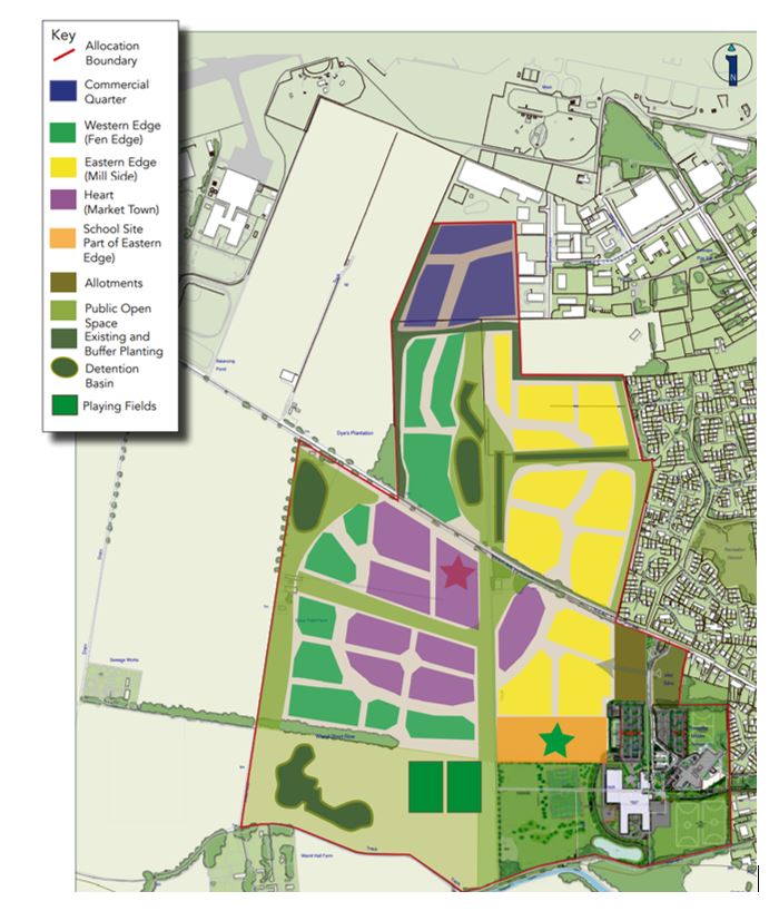
The Character Areas Framework Plan contains four different character areas: Commercial Quarter, Western Edge (Fen Edge), Eastern Edge (Mill Side), and Heart (Market Town). Each will have its own distinctive identify which will be based upon a predominance of certain features including, but not limited to, architectural materials and storey heights. Full information on these areas is detailed on pages 72-87 of the approved Masterplan.

These zones are shown in the Character Areas Plan below.

Natural Environment

A  Preliminary Ecological Appraisal report has been undertaken which identfies the site as primarily comprising arable land, tall ruderal, broadleaved semi- natural woodland, species-poor hedgerow (intact and defunct), scattered trees, semi-improved grassland field margins, improved grassland, introduced shrubs, hardstanding, buildings and fencing.

The findings of initial Habitat Survey work confirm that the habitats onsite have the potential to support bats (roosting and foraging), breeding birds, reptiles, Badger, Hedgehog and common assemblages of invertebrate species. The site is not considered suitable for Great Crested Newt or Hazel Dormouse. Otter and Water Vole are potential present offsite, associated with the River Lark to the south.

Further survey work is being undertaken to support the outline planning application.

The approved Masterplan details a range of recommended mitigation measures, which will be used as a basis for informing the preparation of detailed proposals that will support future planning applications. These are as follows:

  • Retain existing trees and hedgerows where possible as to ensure the preservation of existing habitats on site such as field margins;
  • The open green spaces as part of the proposal will be connected through the use of green corridors as to permit the movement of animals and the continuation of viable populations;
  • Landscaping will be designed to allow bats to continue foraging and roosting on the site;
  • Any work to the riverbanks will be undertaken under a Natural England Licence, ensuring conservation benefit.

Overall, it is the vision for the site to achieve a biodiversity net gain of 10% through the conversion of low value arable land to semi-natural habitats, with green corridors incorporating retained hedgerows and trees, enhanced with additional habitats such as wildflower meadows and tree planting.

The approved Masterplan seeks to ensure that biodiversity net gain is achieved through future planning applications.

The Breckland Special Protection Area (SPA) is within 1.3km of the site and is designated internationally as a protected habitat area. Its aim is to protect breeding and resting sites for threatened bird species in order to ensure the survival of Europe’s vulnerable species.

There is a potential for significant effect to Breckland SPA through recreational disturbance (in the absence of mitigation) from the development of land west of Mildenhall in combination with other planned developments in the District. 

However, the provision of a Suitable Alternative Natural Green Space (a large natural area of public open space, known as a SANG) on site of at least 10 hectares (the equivalent of at least 14 football pitches) is incorporated alongside a range of other measures within the approved Masterplan. This SANG is embedded within the Green Infrastructure Parameter Plan that accompanies the outline planning application. Ultimately, it is the purpose of the SANG to mitigate and offset the potential of adverse impacts from development, not only from within the Masterplan area but in combination with other development in the region.

Historic Environment

There are no listed buildings within the site itself. However, there are a number of heritage assets that surround the application site; for instance, Wamil Hall is a Grade II listed structure situated to its south-west whilst the Church of St. Mary is a Grade 1 listed structure to its south-east.

On its south-eastern boundary the site borders Mildenhall Conservation Area which was designated by West Suffolk Council in 2009.

The initial evidence base gathering and option testing undertaken during the Masterplan preparation process indicated that the provision of significant new areas of green infrastructure alongside retention of key existing landscaped boundaries between these heritage assets and built form in the Masterplan would minimise this impact. In particular, during the first public consultation event Historic England did not consider that the proposal would adversely impact the setting of the Mildenhall Conservation Area. However, they noted that the setting of St. Mary’s Church is important and accordingly this has been treated sympathetically through a landscaping viewing corridor within the approved Masterplan.

A 1st phase of archaeological trial trench evaluation was undertaken in 2022.  An Archaeological evaluation (phase 1 report) has been produced to describe the results of the first stage of the archaeological evaluation of the site.  A second phase is planned post planning submission, and the outcome of the full trench evaluation will inform the final scope of an appropriate archaeological mitigation strategy to be implemented prior to development.

Technical/Existing Constraints

The constraints that would be a relevant consideration in this Masterplan include utilities, odour, noise, flood zones, topography and Public Rights of Way (PROW). Further information about these constraints is detailed within Section 3 of the approved Masterplan document.

Landscape

The approved Masterplan contains a Landscape Framework which has been designed with a focus on a multi-functional living landscape that benefits all. As such, habitats of importance (specifically trees, hedgerows and woodlands) will be retained, protected and enhanced within the scheme to provide improved habitat to protected species in the long term.

This principle is reflected in the Green Infrastructure Parameter Plan that will accompany the outline planning application.

The Landscape Framework, contained within the approved Masterplan, details that it is the intention to retain as much of the existing vegetation as possible. The opportunity exists to increase significantly the level of tree cover in the area, using blocks of woodland along the western edge to help fragment views of the proposed development. It also illustrates a series of interconnecting green corridors is proposed to create a network of landscaped open spaces within the site reducing the prominence of built form and integrating the development into the landscape.

This principle is reflected in the Green Infrastructure Parameter Plan that will accompany the outline planning application.

This principle is reflected in the Green Infrastructure Parameter Plan that will accompany the outline planning application.

Flooding and Drainage

The Environment Agency’s indicative floodplain mapping confirms that the site is classified as being within Flood Zone 1. This means that there is a low probability of fluvial (river) and/or tidal flooding (less than 1 in 1,000-year annual probability of river and sea flooding (<0.1%) in any year). 

The Environment Agency’s indicative mapping for the local area also confirms that the vast majority of the site is not susceptible to pluvial (surface water) flooding. However, there are a small number of isolated of patches which are susceptible to pluvial flooding under the medium-risk scenario (1:100-year event).

The approved Masterplan contains a Drainage Framework which states flood risk will be managed using a network of sustainable drainage systems, which control surface water runoff, ensuring the development does not increase the rate of surface water flows and flood risk on and off-site. These can work in a variety of ways, including: (i) transporting (conveying) surface water at existing greenfield rates through swales (ii) storing water in times of extreme rainfall events in basins, which allows water to soak (infiltrate) into the ground and (iii) on plot permeable areas.

The Green Infrastructure Parameter Plan indicates the creation of multi-functional dry basins along the western edge of the application site, which will be dry except in extreme rainfall events. Whilst not showing on the Parameter Plan, it is the proposed that these will be interlinked by swales, which are shallow, long, thin ditches (roadside and within green areas), a small amount of underground piping and on plot permeable areas.

The exact details of the sustainable urban drainage systems deployed will be fully detailed at the relevant planning application stage.

Public Open Space

The approved Masterplan records that substantial areas of recreation and other forms of open space, such as allotments, parks, sports pitches, will be delivered as supporting infrastructure alongside the provision of new homes.  

This principle of creating a well-connected network of multi-functional open spaces and formal provision exceeding 17 hectares of open space, in addition to over 10 hectares of SANG provision, is reflected in the Green Infrastructure Parameter Plan which is subject to this public consultation.

Numerous types of public open space are provided, including:

  • Play spaces, including a Local Equipped Areas of Play (LEAP) and a Neighbourhood Equipped Areas of Play (NEAP) are proposed to be evenly distributed throughout the Masterplan to give good access to land north and south of West Row Road.
  • A destination play space providing natural play is also included within the SANG.
  • Provision for additional allotments is made adjacent to existing allotments on Sheldrick Way.
  • New sports pitches can be found adjacent to the existing leisure facilities at the Mildenhall Hub to the south east.

The purpose of the green routes is to provide a series of walking and cycling routes through a network of accessible natural green space landscaped corridors, which will also visually integrate this development into the existing landscape and break up the built form.

The green routes are areas of open space that will provide recreation and commuting for pedestrian and cyclists (rather than being solely dependent on the highway network) and provide direct connections east-west, to the riverfront, Mildenhall Hub, the town centre and link to existing public rights of way connecting surrounding villages.

The green corridors will provide the primary connections between new housing, proposed new areas of open spaces, children’s play, a regional SANG, local neighbourhood centre and schools.

The east-west green links will integrate with the St. Mary’s Church view corridor, provide links to Mildenhall Hub and town centre and surrounding neighbourhoods to the east and recreation ground.

Transport and Highways

As detailed in the main FAQs, a vehicular access into the employment land in the northern section of the application site will be created through the existing industrial estate (from Fred Dannatt Road and James Carter Road, including a reconfiguration of a business yard operated by one of the existing businesses, known as Safe Pac). The site will also be accessible at two points along West Row Road which will each be served by a roundabout.

In terms of the internal arrangement, the Access and Movement Parameter Plan provides an indicative alignment of a new spine loop road which will act as the main route of movement for motor vehicles.

Based on available data, the majority of journeys within Mildenhall are made within the West Suffolk and St Edmundsbury areas with trips also made to and from Cambridgeshire, Norfolk and other parts of Suffolk. Generally, journeys would utilise the A11 to travel to and from these locations however it is acknowledged that some trips to and from Cambridgeshire would utilise the smaller more rural routes through villages such as West Row, Freckenham and Chippenham to name a few.

A full analysis of the route options and the amount of traffic likely to use them will form part of the detailed assessment work undertaken for any planning application.  

As illustrated on the Access and Movement Parameter Plan, a network of pedestrian and cyclist routes and facilities will be provided along the site frontage with West Row Road and throughout the entire application site area (segregated from main vehicular routes) to create multiple safe vehicular traffic free access points and encourage non car modes of travel. It would cover key destinations such as the local centre and new Primary school, as well as public open space. The routes will also integrate with connections already established in the surrounding area to maximise connectivity.

These routes will be sited along bands of green infrastructure, creating ‘Green Routes’ which will provide a highly accessible and connected pedestrian and cyclist network in a natural setting. In turn, this will facilitate travel between the different land uses across the site without the car.

The approved Masterplan contains a Public Transport Strategy which promotes the active use of bus travel by users of the development. Bus stops could be placed along the spine road at a strategic intervals so that they are within 400 metres walking distance of the houses, open space, schools and local centre.

The transport evidence prepared for the Local Plan identified that the junctions within Mildenhall would need to be reviewed as part of any planning application coming forward on this or any other site in Mildenhall and therefore a Transport Assessment would need to be prepared to ensure that the junctions within the town as well as those identified as part of the assessment process outside of the town, can cater for this level of development. This assessment will establish the impact of the development and identify any improvements required to support the development. 

It was evident from the first two public consultation events that some local residents have concerns that the existing road network would be unable to cope with the scale of development proposed. Some expressed reservations as to whether the outlined traffic mitigation measures would be sufficient to prevent any adverse highway impacts.

In response, it can be confirmed that the scope of a Transport Assessment which will accompany the outline planning application has been agreed with the Highways Authority. This includes an agreement on the study area, which includes the A1101 Kingsway / B1102 High Street / A1101 North Terrace three-arm mini-roundabout as well others across Mildenhall) and the data (using a strategic planning model which estimates future traffic flows) that will form the basis of the assessment.

Following the termination of the second public consultation, a Transport Note was prepared by highway engineers (AECOM) to provide an initial assessment of the potential impacts of the development upon the capacity of the local and strategic highway network. Its key finding was that further mitigation at the Police Station Square junctions would be required, and therefore set out a range of options that could assist in addressing this issue. In the end, it was concluded that enlarging the existing roundabout and the re-routing of traffic along College Heath Road would provide sufficient capacity to bring it within acceptable limits. On this basis, further work is currently being undertaken to identify potential designs for the enlargement of the roundabout which will also provide enhanced facilities for pedestrians and cyclists  – these details will be resolved at the outline application stage.

Notwithstanding the above, it is worth highlighting that the proposed development will incorporate a range of measures to encourage people to travel by means other than by car (for instance, the creation of a footpath and cycle path network which will integrate into the existing settlement of Mildenhall.

There were some off-site transport infrastructure works which have been provided to facilitate the Mildenhall Hub.  These include:

  • Relocated vehicular access and pedestrian crossing on Queensway;
  • Yellow box at junction of High Street and Queensway;
  • Double yellow lines along Queensway from junction of Queensway to the on street parking bays;
  • New kerbed build out at the junction of High Street and New Street to restrict parking and improved crossing facilities for people crossing New Street;
  • Shared surface area provided on Wamil Way at the rear access to the Hub and covering part of Church Walk. This will be in the form of a raised table, different coloured surface, signage and tactile paving where pedestrians need to cross. This area is to become a more pedestrian dominant area and the improvements are aimed at raising the profile of pedestrians, and encouraging slower vehicle speeds.

Noise

The site is located adjacent to existing residential areas to the east of the site and industrial units to its north, with West Row Road crossing through the application site. These existing uses are not considered to generate significant noise and the site is considered suitable for mixed use development.

The primary sources of noise are likely to be aircraft noise from RAF Lakenheath and RAF Mildenhall and an independent Acoustic Report has been undertaken to inform the approved Masterplan and concluded that there would be no noise-related reason to preclude development.

Residential development is not considered to result in any impacts relating to noise generation. The employment uses could be located in the north of the Masterplan area adjacent to the existing industrial estate where such activity already takes place separate from existing residential uses. The Local Centre is not anticipated to result in any adverse impacts from noise given the nature of the uses proposed. This could however be located close to West Row Road where there is already a number of existing vehicle trips.  Finally, the school and playing fields could be located adjacent to the existing school and sports pitches.

It is anticipated that the reserved matters application will be supported by an Acoustic Design Statement. Its purpose will be to confirm how the adverse impacts of noise will be mitigated and minimised.

Odour

An odour assessment has been carried out using emissions data to determine the likely odour concentrations to which future occupiers of the application site may be exposed to, based on the presence of the Mildenhall Sewage Treatment Works (STW) to the west.

Best practice guidance considers that where predicted odour concentrations are less than 3 OUE/m3 (European Odour Unit per cubic metre of air) then complaints are unlikely to occur. The odour dispersion modelling results indicate that the future occupiers of the application site area are likely to be exposed to odour concentrations within the range 0.1 – 2.6 OUE/m3 as shown by the plan below.

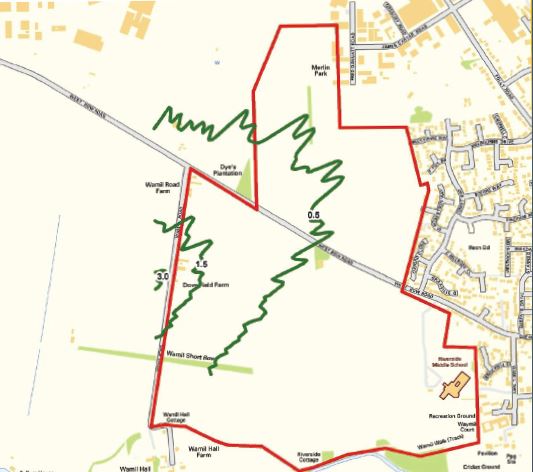
Based on the results of the odour dispersion modelling it is considered the risk of odour nuisance would be minimal, and odour does not represent a constraint to the development. The Development will also be designed with odour in mind and ensure that there are no residential receptors located within 400m of the Mildenhall Sewage Treatment Works (STW).

Infrastructure

This site is allocated within the adopted Local Plan, which has already assessed at a strategic level, the infrastructure requirements to deliver this mixed use allocation.  West Suffolk Council’s Local Plan and supporting evidence base has confirmed that there will be no significant impacts upon the town’s existing infrastructure and localised mitigation can accommodate the development proposed – please refer to the Council’s Local Plan evidence base for further information located at https://www.westsuffolk.gov.uk/planning/Planning_Policies/local_plans/west-suffolk-local-plan-former-forest-heath-and-st-edmundsbury-areas.cfm.

The delivery of the proposed development will incorporate a range of key infrastructure (as identified in the Land Use Parameter Plan) to meets the needs of the local population. This includes a new Primary School as well as a Local Centre that is likely to incorporate complementary services such as retail and community functions. This will all be in addition to the public services and facilities already being provided by the Mildenhall Hub.

In addition to the on-site facilities and services that will be provided by the proposed development, financial contributions will also be made by the developer towards additional infrastructure provision which cover both on-site and off-site requirements.

It is planned that the proposed development will be constructed over a series of stages or phases, rather than in one continuous process. This will help to ensure that key infrastructure is delivered in line with the number of residential units that are constructed.

Pages 128 and 129 of the approved Masterplan provides full information on the five key stages of the development process.

Archive

Please find below links to the versions of the dedicated website that were used for the two previous public consultations.