FAQs
Frequently Asked Questions
We recognise that in the absence of face to face events you may have a number of questions having read our consultation material and therefore we have presented a series of FAQs which we hope will complete a comprehensive overview on this consultation.
This Consultation
This is a public consultation seeking views on the preliminary evidence gathering stages to the production of a Masterplan for the land west of Mildenhall, which is a strategic allocation in the recently adopted Site Allocations Local Plan (SALP) for mixed use development.
The adopted Local Plan (Site Allocations Local Plan 2019) allocates the site as Policy SA4: Focus of growth ‘Land West of Mildenhall’ and requires that a Masterplan is prepared and approved before planning applications can be determined on this site. This allocation means that the principal of a mixed use residential led redevelopment of the site has already been established within the adopted Local Plan. This consultation is seeking views on the vision and implementation strategy of this policy through the Masterplanning process.
This consultation marks the first key milestone towards preparation of a Masterplan for this site. For further information relating to the next stages please see below:
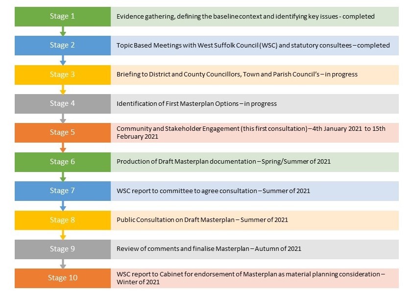
We are consulting with the general public and stakeholders at this preliminary stage of evidence gathering and option testing before progressing to the next stages of the Masterplanning process. This consultation commences on the 4th January 2021 and runs for a period of 6 weeks until the 15th February 2021.
We would like you to receive your feedback and encourage you to complete our online questionnaire.
This consultation is being undertaken by Suffolk County Council (Corporate Property Division) as landowner of the majority of the land allocated within the SALP.
Masterplans
Masterplans are strategic long-term planning documents, which set the vision and implementation strategy for a future development. Masterplans provide a conceptual layout to guide future growth and development and will inform future planning applications. Masterplans focus on site specific strategies such as the scale and layout of development, mix and location of uses, transport and green infrastructure. Masterplans do not undertake detailed design and infrastructure planning as this is undertaken at the planning application stage, which would follow West Suffolk Council’s approval of a Masterplan for this site.
In the context of this public consultation, we are seeking to produce a masterplan that will guide all future development on the land allocated to the west of Mildenhall within the adopted Local Plan. In practice, this means that any future planning applications, for parts or the whole site, will be required to ensure general conformity to the governing principles agreed within the masterplan.
The creation of a masterplan will set out a vision and strategy for the long term development of this site, and provide a conceptual master plan framework which will in turn help to raise and set the standards for future design and infrastructure provision.
The adopted Local Plan (Site Allocations Local Plan 2019) allocates the site as Policy SA4: Focus of growth ‘Land West of Mildenhall’ and seeks mixed use development of this 97ha site comprising of the following indicative uses:
- 1,300 dwellings, 30% affordable;
- 5ha employment minimum;
- Primary School and Early Years;
- 10ha of Suitable Alternative Natural Green Space (SANG)
- Strategic Open Space, Allotments;
- Local Centre; and
- Public Services and Leisure Facilities
More information concerning this allocation can be found in West Suffolk District Council’s Site Allocations Local Plan located here: Final-SALP-September-2019.pdf (westsuffolk.gov.uk)
Nature of The Proposals
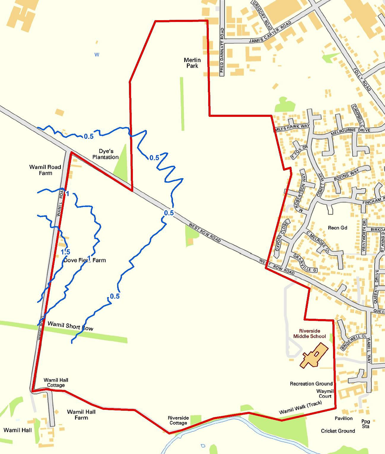
The proposed Masterplan relates to land to the west of Mildenhall. The site is an area of 97ha of arable land which adjoins the existing settlement of Mildenhall along its western edge. The location of the site can be seen here .
A masterplan for the development of approximately 1300 dwellings, 5 hectares of employment land, a new Primary School (including early years provision), Local Centre (containing community uses and retail), 80 bed Adult Care Services (providing supported living for adults) and 10ha of Suitable Alternative Natural Green Space (SANG), which is a form of open space that encourages visitor recreation as part of site specific ecological mitigation to avoid disturbance to protected habitats.
This Masterplan is seeking to support the delivery of up to 1300 homes alongside the provision of 30% affordable homes. This will include provision of approximately 80 bed Adult Care Services, which is supported living for adults. However, the final number of homes to be provided will be confirmed within the subsequent planning applications that would follow the approval of the proposed Masterplan.
The exact housing mix and type will be established in subsequent planning applications once the Masterplan has been approved. Any housing mix will have regard to the latest evidence on housing needs. It is envisaged that the full range of housing needs can be provided on site.
This will include traditional office, industrial and storage uses that will be complimentary to the existing commercial uses that operate from the existing employment area in the north of the town.
This could include community uses, such as dentist, community hall, alongside local shopping and services such as a small convenience shop, launderettes, takeaways and other appropriate uses. The exact type and size of uses will be determined through future planning applications.
Suffolk County Council will deliver a new Primary School of 420 pupil places and supporting Early Years of 60 places to meet the needs of these new houses. The existing and expanding secondary school and sixth form on the land at The Mildenhall Hub will accommodate older children from this development.
The public services and leisure facilities sought by the Local Plan is being proactively delivered at the Midenhall Hub, which is a public services project to create a ‘One Public Estate’ within a shared services hub (more information https://www.mildenhallhub.info/info/).
Yes. The Masterplan seeks to provide a well-connected network of multi-functional open spaces. The current framework plans demonstrate provision of open space exceeding 17 hectares, which is in addition to over 10 hectares of Suitable Alternative Natural Green Space (SANG) provision.
Play spaces will be included and it would be appropriate that they are evenly distributed throughout the Masterplan to give good access to land north and south of West Row Road. A destination play space is included within the SANG.
It is proposed that an internal network of ‘safe routes’ throughout the application site will ensure connections to key destinations contained within it, such as Mildenhall Hub and the new Primary school. The proposal will also ensure linkages with the existing Public Rights of Way network to facility wider accessibility for recreation and to access services and facilities in the town.
Provision for additional allotments is made adjacent to existing provision and sports pitches can be found adjacent to the existing leisure facilities at the Mildenhall Hub to the south east.
The public open spaces proposed will be available for use by the general public.
The promoters would seek to ensure through the Masterplan that subsequent planning applications reflect current and future planning policy and regulations in respect of climate change.
The following key principles will be considered through the masterplan and planning process:
Urban Design
- Pedestrian and cycle friendly urban design and layout that encourages non car use
- Provision of secure cycle parking facilities
- Connections to existing PROWs and creation of new PROWs
- New connections to public transport routes beyond the allocated site
- Strategic integration of SUDS into masterplan
- Formation of green corridors, green infrastructure and wildlife corridors throughout the site
Housing Design & Build Standards
- Construct new dwellings to BREEAM Code for Sustainable Homes standard
- Utilise low carbon heating systems and renewable energy sources
- Fabric first construction principles and energy efficient design
- Siting and orientation of buildings and thermal comfort considered as part of design
- On site generation
- Energy infrastructure to allow for electrical vehicle charging and peak demand management
- Water efficiency and conservation on site through water meters, low flow fittings, water efficient appliances and provision of water butts
Materials and waste
- Reduced Embodied carbon through local sourcing of materials and reduction of waste where possible
Timing And Programme
It is anticipated that the proposed Masterplan will be submitted to the West Suffolk District Council (WSDC) in the Autumn of 2021 seeking approval of the Masterplan with its approval before the end of 2021.
Below is a broad indication of the Masterplan programme:
It is anticipated that planning applications could be submitted for development on parts of the site around Spring 2022 and a decision reached before the end of 2022.
Whilst a number of key decisions are yet to made in terms of who will deliver this development it is anticipated that construction will not commence until 2024 with delivery of the first homes in 2025/2026.
It is anticipated that this development could take up to 10 years to be completed from commencement of the first phases of development.
Natural Environment
A Preliminary Ecological Appraisal report has been undertaken which identfies the site as primarily comprising arable land, tall ruderal, broadleaved semi- natural woodland, species-poor hedgerow (intact and defunct), scattered trees, semi-improved grassland field margins, improved grassland, introduced shrubs, hardstanding, buildings and fencing.
The findings of initial Habitat Survey work confirm that the habitats onsite have the potential to support bats (roosting and foraging), breeding birds, reptiles, Badger, Hedgehog and common assemblages of invertebrate species. The site is not considered suitable for Great Crested Newt or Hazel Dormouse. Otter and Water Vole are potential present offsite, associated with the River Lark to the south.
Further survey work will be undertaken throughout 2021.
The following mitigation will be recommended in this Masterplan and used as a basis for informing the preparation of detailed proposals that will support a planning application:
- Retain existing trees and hedgerows where possible;
- Areas of semi-natural habitat such as meadows, ponds woodlands, hedgerows could be created within the scheme;
- The development should include incorporating plants that are beneficial to wildlife;
- Bird and bat bricks and boxes should be incorporated within the scheme;
- Log piles could be placed in connectivity to the any areas of semi- natural habitat within the proposals, such as woodland, meadows ponds etc;
This Masterplan will seek to ensure that biodiversity net gain is achieved through future planning applications.
The Breckland Special Protection Area (SPA) is within 1.3km of the site and is designated internationally protected habitat areas within close proximity to Mildenhall with the aim to protect breeding and resting sites for threatened bird species in order to ensure the survival of Europe’s vulnerable species.
There is a potential for significant effect to Breckland SPA through recreational disturbance (in the absence of mitigation) from the development of land west of Mildenhall in combination with other planned developments in the District. However, the provision of a Suitable Accessible Natural Green Space (a large natural area of public open space known as a SANG) on site of at least 10 hectares (the equivalent of at least 14 football pitches) alongside other measures within this Masterplan will mitigate and offset the potential of adverse impacts from development, not only from within the Masterplan area but in combination with other development in the region.
Historic Environment
There are no listed buildings on the site but two designated heritage assets close by, the first of which is a Grade II listed building known as Wamil Hall located to the south west of the site and the second relates to a small part of the Mildenhall Conservation Area, that abuts the south east corner of the site.
The initial evidence base gathering and option testing indicates that the provision of significant new areas of green infrastructure alongside retention of key existing landscaped boundaries between these heritage assets and built form in the Masterplan can reduce the impact. These matters will be given further due consideration during the refinement of the Masterplan process.
An initial archaeological assessment has identified that no designated assets of archaeological interest are located within the site; so no designated archaeological remains will therefore be adversely or physically affected by development within the Site.
The heritage assets recorded in the vicinity of the site demonstrate that this part of Mildenhall has been inhabited/used in multiple periods from the Iron Age onward. A geophysical survey has been undertaken to inform the design process and any features identified are likely to be mainly associated with the agricultural history of the site and would most likely be of low to medium significance depending on the levels of preservation encountered.
These matters will be given further due consideration during the refinement of the Masterplan process.
Technical/Existing Constraints
A review of existing technical data and site specific base line assessments has been undertaken at this evidence gathering stage of the process to inform key decisions within the Masterplan.
The constraints that would be a relevant consideration in this Masterplan are highlighted on our presentation boards and include: utilities, odour, noise, flood zones, topography and Public Rights of Way (PROW).
Our initial investigations have not identified any significant constraints to fulfilling the Local Plan objectives for this site as set out in our exhibition material.
Landscape
The intention is to retain as much of the existing vegetation as possible. The opportunity exists to increase significantly the level of tree cover in the area, using blocks of woodland along the western edge to help fragment views of the proposed development.
A series of interconnecting green corridors is proposed to create a network of landscaped open spaces within the site reducing the prominence of built form and integrating the development into the landscape.
The landscape framework has been designed with a focus on a living landscape that benefits all. As such, habitats of importance (specifically trees, hedge rows and woodlands) will be retained, protected and enhanced within the scheme to provide improved habitat to protected species in the long term.
A network of interconnected green spaces is proposed around the retained vegetation and Rights of Way. This would link together the existing features of the site and provide a landscape framework for the development, and a new edge and gateway into Mildenhall.
Flooding And Drainage
The Environment Agency’s indicative floodplain mapping confirms that the site is classified as being within Flood Zone 1. This means that there is a low probability of fluvial (river) and/or tidal flooding (less than 1 in 1,000-year annual probability of river and sea flooding (<0.1%) in any year).
The Environment Agency’s indicative mapping for the local area also confirms that the vast majority of the site is not susceptible to pluvial (surface water) flooding. However, there are a small number of isolated of patches which are susceptible to pluvial flooding under the medium-risk scenario (1:100-year event).
This will be achieved using a network of sustainable drainage systems, which control surface water runoff, ensuring the development does not increase the rate of surface water flows and flood risk on and off-site. These can work in a variety of ways, including: (i) transporting (conveying) surface water at existing greenfield rates through swales (ii) storing water in times of extreme rainfall events in basins, which allows water to soak (infiltrate) into the ground and (iii) on plot permeable areas.
The exact details of the sustainable urban drainage systems deployed will be fully detailed at the planning application stage and for this Masterplan we identify the key principles only.
The drainage strategy for this Masterplan follows Sustainable Urban Drainage System best practice and proposes a network of dry basins, which will be dry except in extreme rainfall events, interlinked by swales, which are shallow, long, thin ditches (roadside and within green areas), a small amount of underground piping and on plot permeable areas before discharging into the River Lark at natural surface water flow rates.
Public Open Space
Substantial areas of recreation and other forms of open space, such as allotments, parks, sports pitches, will be delivered as supporting infrastructure alongside the provision of new homes within this Masterplan. The exhibition material illustrates how recreation and open spaces could be provided and integrated within the wider landscape framework and your feedback will inform the evolution of the Masterplan.
The Masterplan provides a well-connected network of multi-functional open spaces and formal provision exceeding 17 hectares of open space in addition to over 10 hectares of SANG provision. Play spaces, known as Local Equipped Areas of Play (LEAP) and Neighbourhood Equipped Areas of Play (NEAP) are proposed to be evenly distributed throughout the Masterplan to give good access to land north and south of West Row Road and form part of larger multi-functional open spaces. A destination play space providing natural play is also included within the SANG.
Provision for additional allotments is made adjacent to existing allotments on Sheldrick Way and new sports pitches can be found adjacent to the existing leisure facilities at the Mildenhall Hub to the south east.
The purpose of the green routes is to provide a series of walking and cycling routes through a network of accessible natural green space landscaped corridors, which will also visually integrate this development into the existing landscape and break up the built form.
The green routes are areas of open space that will provide recreation and commuting for pedestrian and cyclists (rather than being solely dependent on the highway network) and provide direct connections east-west to the riverfront, Mildenhall Hub, the town centre and link to existing public rights of way connecting surrounding villages.
The green corridors will provide the primary connections between new housing, employment and proposed new areas of open spaces, children’s play, a regional SANG, local neighbourhood centre and schools.
The east-west green links will integrate with the St. Mary’s Church view corridor, provide links to Mildenhall Hub and town centre and surrounding neighbourhoods to the east and recreation ground.
Transport And Highways
This consultation illustrates an indicative access and movement strategy, which is presented at a broad strategic level, relative to the evidence gathering stage of the Masterplan process being considered.
The illustrative material indicates the main movement infrastructure (pedestrian, cycle and vehicular) and where it could be located in this Masterplan to achieve a high level of integration with the town.
Two new vehicular accesses are currently indicated from West Row Road in the form of two new compact roundabouts to serve the land north and south of West Row Road. A new spine loop road between the roundabouts will serve the land to the south of West Row Road. A new access road will also serve the land to the north of West Row Road and provide a connection to Fred Dannantt Road.
Illustrative sections of the minimum widths of the type of road networks that will serve the development (in addition to the green routes) is shown for information.
A network of enhanced pedestrian and cyclist routes and facilities will be provided along the site frontage with West Row Road and throughout the entire Masterplan area segregated from main vehicular routes to provide to create multiple safe vehicular traffic free access points and encourage non car modes of travel.
Green Routes will provide a highly accessible and connected pedestrian and cyclist network in a natural setting alongside recreation uses in vehicular free areas. Please view our exhibition material for more information.
It is proposed that the Masterplan will create a network of ‘safe routes’ that facilitate travel between the different land uses across the site without the car. It would cover key destinations such as the local centre and new Primary school, as well as public open space. The routes will also integrate with connections already established in the surrounding area to maximise connectivity.
Improved bus service provision is already being delivered on the adjacent land at the Mildenhall Hub, which will provide new stops in this location. Bus services will travel within and through the development using the distributor road providing a connection between the site and the town centre as well as other locations. Consideration will be given to the provision of a ‘Dial-a-Bus’ service which provides residents with greater access to bus based travel to the town.
Based on available data, the majority of journeys within Mildenhall are made within the West Suffolk and St Edmundsbury areas with trips also made to and from Cambridgeshire, Norfolk and other parts of Suffolk. Generally journeys would utilise the A11 to travel to and from these locations however it is acknowledged that some trips to and from Cambridgeshire would utilise the smaller more rural routes through villages such as West Row, Freckenham and Chippenham to name a few. A high level assessment has been undertaken to inform the masterplan development however a full analysis of the route options and the amount of traffic likely to use them will form part of the detailed assessment work undertaken for any planning application. This will be informed by the SCC traffic model.
The transport evidence prepared for the Local Plan identified that the junctions within Mildenhall would need to be reviewed as part of any planning application coming forward on this or any other site in Mildenhall and therefore a Transport Assessment would need to be prepared to ensure that the junctions within the town as well as those identified as part of the assessment process outside of the town, can cater for this level of development. This assessment will identify any improvements required to support the development. This assessment is undertaken as part of the preparation of the planning application which will commence following the Consultation and Masterplan development stage.
There are some off-site transport infrastructure works which have been proposed to facilitate Mildenhall Hub however the exact detail has not yet been agreed with the highway authority. These could include:
- Relocated vehicular access and pedestrian crossing on Queensway;
- Yellow box at junction of High Street and Queensway;
- Double yellow lines along Queensway from junction of Queensway to the on street parking bays;
- New kerbed build out at the junction of High Street and New Street to restrict parking and improved crossing facilities for people crossing New Street;
- Removal of the No Cycling rule on Church Walk but new bollards and droppable bollards provided to reduce speed of cyclists;
- Shared surface area provided on Wamil Way at the rear access to the Hub and covering part of Church Walk. This will be in the form of a raised table, different coloured surface, signage and tactile paving where pedestrians need to cross. This area is to become a more pedestrian dominant area and the improvements are aimed at raising the profile of pedestrians, and encouraging slower vehicle speeds.
The transport evidence prepared for the Local Plan demonstrated that there would not be a need for bypass to the west of Mildenhall to cater for the growth allocated within the current local plan. There are requirements for improvements within the town, including improved facilities and routing for pedestrians and cyclists, traffic management measures, as well possible re-routing of HGVs away from the Town Centre.
- Footways and cycleways connecting to the existing networks;
- Crossing facilities at points where footways and cycleways cross carriageways;
- Cycle parking facilities;
- New vehicular access points on West Row Road in the form of roundabouts;
- Parking management;
- Bus stops provided within the development on the distributor road; and
- Electric vehicle charging points.
- Traffic management measures around Police Station Square;
- Parking management;
- Promotion of alternate traffic route along College Heath Rd;
- Improved pedestrian and cycle facilities within town centre; and
- Rationalisation of Queensway / High Street / New Street area.
West Row Road is relatively lightly trafficked at present, and of sufficient size to cater for the expected increase in traffic. There are improvements proposed as part of the masterplan along the site frontage, including extending the current speed restrictions further west, with a gateway entry to Mildenhall. The proposed scheme will create a more urban feel for this section of the road. Two new roundabouts are proposed to provide site access from West Row and these will also provide a traffic calming feature along this section. Any design related changes to West Row Road in the vicinity of the development will be undertaken in accordance with the appropriate guidance documents and form part of the assessment within any planning application, and will be subject to agreement with the highway authority.
Noise
The site is located adjacent to existing residential areas to the east of the site and industrial units to its north, with West Row Road crossing through the application site. These existing uses are not considered to generate significant noise and the site is considered suitable for mixed use development.
The primary sources of noise are likely to be aircraft noise from RAF Lakenheath and RAF Mildenhall and an independent Acoustic Report has been undertaken to inform the Masterplan and concluded that there would be no noise-related reason to preclude development in accordance with the indicative Master Framework Plan option being tested through this consultation.
This exhibition indicates the airbase noise contours which fall outside of the Masterplan site.
It is not considered that site specific mitigation is required to protect the development from noise sources beyond usual acoustic treatment that is secured through building fabric and design, such as double glazed windows.
Residential development is not considered to result in any impacts relating to noise generation. The employment uses could be located in the north of the Masterplan area adjacent to the existing industrial estate where such activity already takes place separate from existing residential uses. The Local Centre is not anticipated to result in any adverse impacts from noise given the nature of the uses proposed. This could however be located close to West Row Road where there is already a number of existing vehicle trips. Finally, the school and playing fields could be located adjacent to the existing school and sports pitches.
Any future planning application will be supported by an Acoustic Design Statement. Its purpose will be to confirm how the adverse impacts of noise will be mitigated and minimised.
Odour
An odour assessment has been carried out using emissions data to determine the likely odour concentrations to which future occupiers of the Masterplan area may be exposed to, based on the presence of the Mildenhall Sewage Treatment Works (STW) to the west.
Best practice guidance considers that where predicted odour concentrations are less than 3 OUE/m3 (European Odour Unit per cubic metre of air) then complaints are unlikely to occur. The odour dispersion modelling results indicate that the future occupiers of the Masterplan area are likely to be exposed to odour concentrations within the range 0.1 – 2.6 OUE/m3 as shown by the plan below.
Based on the results of the odour dispersion modelling it is considered the risk of odour nuisance would be minimal, and odour does not represent a constraint to the Masterplan area. The Development will also be designed with odour in mind and ensure that there are no residential receptors located within 400m of the Mildenhall Sewage Treatment Works (STW).
Infrastructure
This site is allocated within the adopted Local Plan, which has already assessed, at a strategic level, the infrastructure requirements to deliver this mixed use allocation. West Suffolk Council’s Local Plan and supporting evidence base has confirmed that there will be no significant impacts upon the town’s existing infrastructure and localised mitigation can accommodate the development proposed – please refer to the Council’s Local Plan evidence base for further information located https://www.westsuffolk.gov.uk/planning/Planning_Policies/local_plans/west-suffolk-local-plan-former-forest-heath-and-st-edmundsbury-areas.cfm.
Statutory undertakers, consultees and stakeholders are being consulted through this Masterplan process which will inform strategic infrastructure planning, however, detailed assessment and infrastructure modelling will not take place until the planning application stage, following approval of this Masterplan where detailed proposals will be assessed.