FAQs
Frequently Asked Questions
We recognise that you may have a number of questions having read our consultation material and therefore we have presented a series of FAQs which we hope will complete a comprehensive overview on this consultation.
This Consultation
This consultation concerns Suffolk County Council’s proposal to submit an outline planning application, for a site known as Land West of Mildenhall, to West Suffolk Council for approval. The site a strategic allocation in the recently adopted Site Allocations Local Plan (SALP) for mixed use development under Policy SA4: Focus of growth ‘Land West of Mildenhall’.
Two public consultation events have previously been held, in 2021 and 2022 respectively, in relation to the site known as Land West of Mildenhall. They were related to the preparation of a Masterplan – a long-term strategic document which incorporated: (i) a vision for the future development of the site, and (ii) a set of framework plans (or site-specific strategies) to guide the implementation of the development, such as the intended arrangement of land uses.
The first public consultation event focused upon the background evidence base; in other words, the technical constraints (e.g. the local transport network) and opportunities (e.g. the creation of new spaces for public recreation) which would inform the production of this Masterplan. A variety of feedback was received from both the general public and statutory consultees (e.g. Natural England). The feedback received from this event helped to inform the detail of the Masterplan.
The second public consultation event focused upon the contents of the draft Masterplan document, such as its overall vision, constraints and opportunities, development frameworks (site-specific strategies and phasing strategy). As before, direct feedback was received from the general public and statutory consultees which assisted the project team in revising the final Masterplan.
This public consultation seeks to obtain your views on an outline planning application for a site allocated for mixed use development within the SALP known as Land West of Mildenhall. The outline planning application seeks approval from the local planning authority on the principle of constructing mixed-use development on the site.
This means detailed matters, such as the access, scale, appearance, landscaping, and layout of development parcels, will be decided in future planning applications (called Reserved Matters applications). However, this outline planning application does include detailed proposals for a vehicular access into the proposed new employment land (from Fred Dannatt Road and James Carter Road), alongside the reconfiguration of the yard of one of the existing businesses, known as Safe Pac, to facilitate access.
Given this context, this public consultation event is accompanied by a series of Parameter Plans which provide a high-level overview of how the application site could be developed. These cover the following topics: land use, density, building height, landscape and open spaces, and access and movement.
Whilst we would welcome feedback on all aspects in relation to the proposed outline planning application, the table below has been prepared to outline the type of feedback that can have the greatest influence over the process.
Feedback that can influence the final outline planning application | Feedback that cannot influence the final outline planning application |
|
|
This consultation commences on Monday the 6th February 2023, running until Monday the 20th March 2023.
We would like you to receive your feedback and encourage you to complete our online questionnaire.
This consultation is being undertaken by Suffolk County Council.
Contextual Background
An application for outline planning permission seeks to obtain approval from the local planning authority (in this instance, West Suffolk Council) for the principle of constructing a certain development on a site.
Outline planning applications can also incorporate detailed matters which include means of access, layout, scale, appearance, and landscaping. It should be noted that aside from the details shown in relation to realignment of Fred Dannatt Road and associated changes, these detailed matters are not being considered within the outline planning application that is subject to this public consultation.
The outline planning application will be accompanied by a Site Location Plan showing the boundaries of the proposed development in relation to its surroundings. It will also be accompanied by a series of Parameter Plans – drawings which provide a high-level overview as to how the application site could be developed. These typically cover the following topics: land use, density, building height, landscape and open spaces, and access and movement.
It should be noted that, for the purposes of this public consultation, the only formal plans that will be approved by the local planning authority will be the Site Location Plan and Land Use Parameter Plan.
The remaining Parameter Plans are being submitted primarily to illustrate that application site is capable of accommodating the level of development proposed in way that will meet adopted development standards (for instance, garden sizes and public open space requirements).
The exact series of documents which will accompany the architectural drawings is yet to be finalised. At this stage, however, we are able to confirm that it will include:
- A Planning Statement which assesses how the scheme is in line with local and national planning policies, as well as the guiding principles contained within the approved Masterplan.
- A Design & Access Statement which discusses the historical timeline behind the concept for the proposal and provides more detailed information about the scheme. It will likely provide some drawings showing the possible design of dwellings and suggest a possible mix of housing units.
- A Statement of Community Involvement which explains how the local community were involved in the preparation of the outline planning application, and the steps that were taken to encourage this involvement.
It should be noted that a legal agreement (called a Section 106 agreement) will also be prepared to accompany the outline planning application. It will detail a lawfully binding commitment on behalf of the developer to meet a range of obligations, including financial contributions to improve local infrastructure.
The adopted Local Plan (Site Allocations Local Plan 2019) which allocates the site for mixed-use development under Policy SA4: Focus of growth ‘Land West of Mildenhall’ required that a Masterplan be prepared and approved before planning applications can be determined on this site.
Beyond this, the preparation of this long-term strategic document will act as a guide to developers by providing conceptual frameworks (site-specific strategies) as well an implementation strategy. In turn, this is intended to help raise and set the standards for design and infrastructure provision contained within future planning applications.
A Masterplan was previously prepared by the project team, the content of which was influenced by two previous public consultations. The document incorporated (i) a vision for the future development of the site, and (ii) a set of framework plans (or site-specific strategies) to guide the implementation of the development, such as the suggested arrangement of land uses. In essence, the document provided a framework to guide the preparation and assessment of future planning applications.
The final Masterplan was eventually approved by the local planning authority in November 2022. Consequently, it will be necessary for the outline planning application that is submitted to the local planning authority to demonstrate how the scheme broadly complies with the guiding principles contained within the document.
The adopted Local Plan (Site Allocations Local Plan 2019) allocates the site as Policy SA4: Focus of growth ‘Land West of Mildenhall’ and seeks mixed use development of this 97ha site comprising of the following indicative uses:
- 1,300 dwellings, 30% affordable;
- 5ha employment minimum;
- Primary School and Early Years;
- 10ha of Suitable Alternative Natural Green Space (SANG)
- Strategic Open Space, Allotments;
- Local Centre; and
- Public Services and Leisure Facilities
More information concerning this allocation can be found in West Suffolk District Council’s Site Allocations Local Plan located here: Final-SALP-September-2019.pdf (westsuffolk.gov.uk)
Timing And Programme
It is anticipated that the proposed outline planning application will be submitted to the West Suffolk in the Summer of 2023, with a decision by the end of 2023.
Whilst a number of key decisions are yet to made in terms of who will deliver this development it is anticipated that construction will not commence until 2025 with delivery of the first homes in 2026/2027.
Nature Of The Proposals
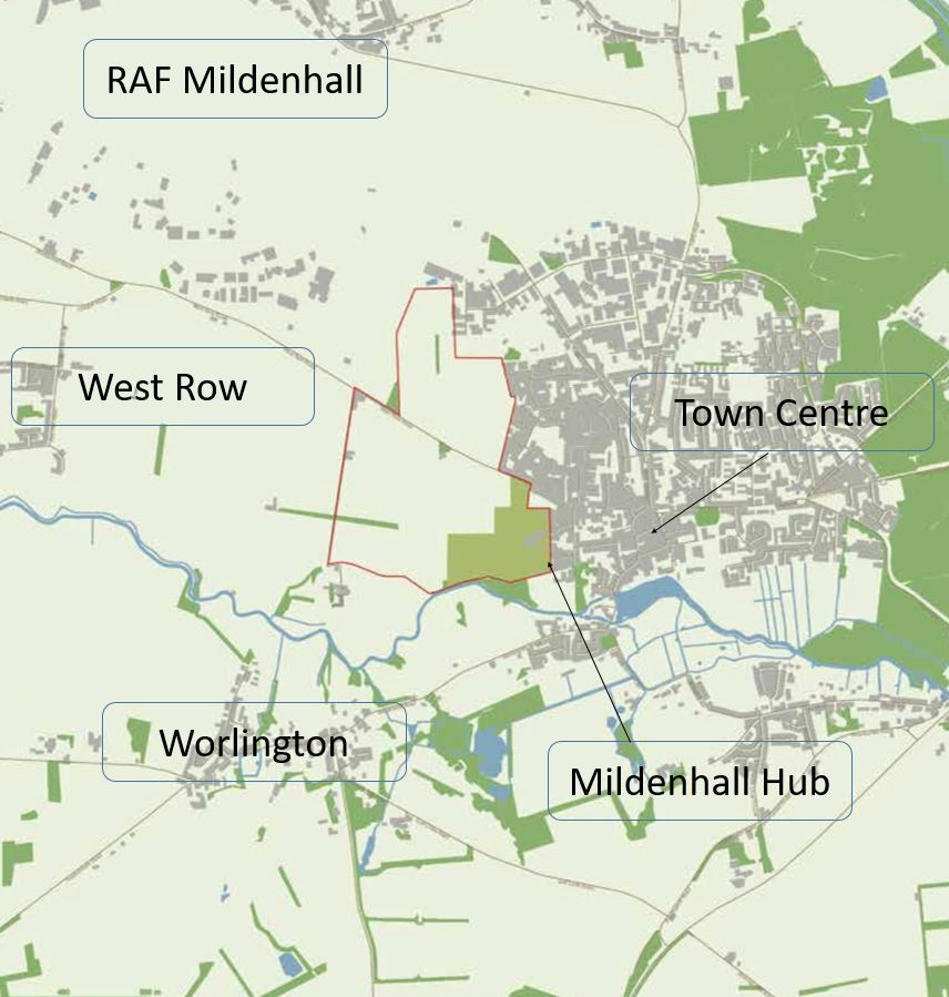
The proposed outline planning application relates to land to the west of Mildenhall. The site is an area of arable land which adjoins the existing settlement of Mildenhall along its western edge. The location of the site can be seen here
An outline planning application for the development of up to 1000 dwellings, 5 hectares of employment land, a new Primary School (including early years provision), Local Centre (containing community uses and retail), 80 bed Adult Care Services (providing supported living for adults) and 10ha of Suitable Alternative Natural Green Space (SANG), which is a form of open space that encourages visitor recreation as part of site specific ecological mitigation to avoid disturbance to protected habitats.
The outline planning application is seeking to provide up to 1000 homes including the provision of 30% affordable homes. This will include provision of approximately 80 bed Adult Care Services, which is supported living for adults. However, the final number of homes to be provided will be confirmed within the subsequent reserved matters application.
The exact housing mix and type will be established within a subsequent reserved matters planning application. Nevertheless, it is intended that the final outline planning application will provide an indicative housing mix which can cater to the full range of housing needs.
This will include traditional office, industrial and storage uses that will be complimentary to the existing commercial uses that operate from the existing employment area in the north of the town. The exact uses of the employment land (potentially covering Use Classes such as B2 – General Industry – and B8 – Storage and Distribution) will be laid out in a future reserved matters planning application.
This could include local shops, such as dentist, a small convenience shop, laundrettes, takeaways and an early years facility. The exact type and size of uses will be determined through future planning applications.
Suffolk County Council will deliver a new Primary School of 420 pupil places alongside an Early Years of 60 places, and potentially a further Early Years facility to meet the needs of these new houses. The existing and expanding secondary school and sixth form on the land at The Mildenhall Hub will accommodate older children from this development.
The public services and leisure facilities sought by the Local Plan has already been proactively delivered at the Mildenhall Hub, which is a public services project to create a ‘One Public Estate’ within a shared services hub (more information https://www.mildenhallhub.info).
Yes. As shown on the Green Infrastructure Parameter Plan, the scheme seeks to provide a well-connected network of multi-functional open spaces. Further information about open space provision is contained within the ‘Parameter Plans’ sections of these FAQs.
The public open spaces proposed will be available for use by the general public.
Parameter Plans
Five Parameter Plans are being provided as part of this public consultation which covers the following topics: land use, density, building height, landscape and open spaces, and access and movement.
These Parameter Plans are submitted for approval to establish a framework for future detailed reserved matters applications.
Therefore, the detail of these matters will be assessed at a subsequent stage should outline planning permission be granted.
The proposed Land Use Parameter Plan shows how the different land uses will be spread across the site. It shows that the northernmost part of the application site is to be reserved as employment land which will include, but is not strictly limited to, general industry (B2 Use Class), storage and distribution businesses (B8 Storage and Distribution Use Class) and office or research and development functions (Use Class E(g)). The central component of the application site will include the provision of housing, a local centre (likely to incorporate retail and possibly community functions), and adult care services.
The south-eastern corner of the site will be reserved for a new primary school (with pre-school accommodation). Meanwhile, the south-western corner will provide Suitable Alternative Natural Greenspace (SANG) – a large natural area of public open space.
These land uses will be interspersed by a supporting road network (including a spine road) and green infrastructure.
The proposed Density Parameter Plan shows a range of different housing densities (measured in dwellings per hectare – dph). It reveals that the highest concentration of dwellings is proposed within the core of the application site (nearest to the local centre and adjacent to the existing settlement of Mildenhall), with the lowest concentration of houses nearest the western and southern edge of the application site.
The proposed Storey Heights Parameter Plan shows the envisaged maximum height of buildings across the site. It illustrates that the tallest buildings will be restricted to the central core (up to 4 storeys) and the employment land (with a total height of up to 15 metres, which is equivalent to 4 storeys). In contrast, the lowest buildings will be sited on the eastern and western periphery of the site (up to 2.5 storeys).
The proposed Green Infrastructure Parameter Plan shows the overall extent of land which will be used for open space. This includes a new natural greenspace buffer on both the eastern and western edge of the application site (which are intended to visually integrate the development into the existing landscape). This is accompanied by areas of informal open space, recreation grounds, and dedicated areas of play space. These areas will be available for the enjoyment of the future users of the development as well as the existing residents of Mildenhall and its surrounds.
As indicated in the approved Masterplan, this green infrastructure will accommodate a series of walking and cycling routes that will create a network for commuting pedestrians and cyclists to provide the most direct connections east-west, to the riverfront, Mildenhall Hub, the town centre and link to existing public rights of way connecting surrounding villages.
The proposed Access and Movement Parameter Plan shows the main indicative routes through which motorists, cyclists and pedestrians will access and move around the application site. This includes two new access junctions on West Row Road, and a vehicular access into the employment land at the northern section of the application site through the existing industrial estate (from Fred Dannatt Road and James Carter Road, including a reconfiguration of a business yard operated by one of the existing businesses, known as SafePac).
The site will also be accessible at two points along West Row Road which will each be served by a roundabout; the easternmost roundabout will provide access to the northern and southern sections of the development, whilst the westernmost roundabout will provide access to the southern section of the development (which will connect to the eastern roundabout via a spine road). These roundabouts will be designed to the adopted standards to ensure that vehicles can enter and leave the relevant sections of the development safely.
Beyond this, a network of footpaths and cycle paths will enable residents and users to move around the development and into surrounding areas by means other than a motor vehicle. This will include direct connections east-west to the riverfront, Mildenhall Hub, the town centre and link to existing public rights of way connecting surrounding villages.
A Transport Assessment is currently being prepared that will accompany the final outline planning application. The document will assess the impacts of the development for all modes of transport and set out a range of potential improvements to local transport infrastructure which could include, for instance, promoting the redirection of traffic flows around the town and reducing the speed limit along West Row Road as well as providing enhanced facilities for walking and cycling.